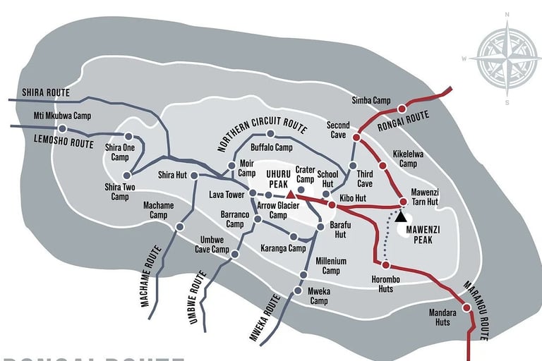
RONGAI ROUTE
The Rongai Route is the only route that approaches Mount Kilimanjaro from the north, near the Kenyan border. It is known for its dry, quiet, and less crowded trails, making it ideal for climbers who prefer a more remote experience. The route offers a gentle ascent and is often chosen for its gradual slope and high summit success rate.
Key Facts
Route Type: One-way / Ascend from the North, descend via the South (Marangu Route)
Starting Point: Rongai Gate (near the Kenya-Tanzania border)
Ending Point: Marangu Gate (southern side)
Distance: ~73 kilometers (45 miles)
Duration: 6 to 7 days
Difficulty: Moderate
Success Rate: High (especially with 7-day itinerary)
Crowds: Low (quiet and remote)
Scenery: Diverse – forest, moorland, alpine desert, and arctic summit
Accommodation: Tents (except last night in Mandara Huts)
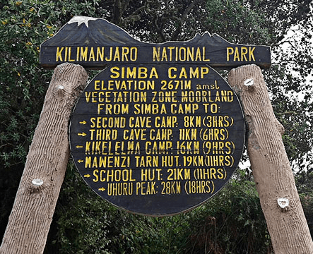
Day 1: Rongai Gate to Simba Camp
Starting Altitude: ~2,000m (6,560 ft)
Ending Altitude: 2,625m (8,610 ft)
Hiking Time: 3–4 hours
Habitat: Montane Forest
A gentle walk through corn and potato fields, followed by forest where you may spot Colobus monkeys.
Day 2: Simba Camp to Second Cave Camp
Altitude: 2,625m to 3,450m (11,320 ft)
Hiking Time: 6–7 hours
Habitat: Moorland
Gradual climb with great views of Kibo and the Eastern Ice Fields.
Day 3: Second Cave to Kikelewa Camp
Altitude: 3,450m to 3,600m (11,810 ft)
Hiking Time: 3–4 hours
Habitat: Moorland
Shorter day, steep in parts; vegetation becomes sparse.
Day 4: Kikelewa to Mawenzi Tarn Camp
Altitude: 3,600m to 4,330m (14,210 ft)
Hiking Time: 4–5 hours
Habitat: Alpine Desert
Scenic hike beneath the towering spires of Mawenzi. Camping near a small tarn (lake) at the base of Mawenzi.
Day 5: Acclimatization Day at Mawenzi Tarn
Altitude: 4,330m
Hiking Time: 3–4 hours (optional hikes)
Acclimatization hikes around Mawenzi. Crucial for adjusting to the altitude before summit attempt.
Day 6: Mawenzi Tarn to Kibo Hut
Altitude: 4,330m to 4,700m (15,420 ft)
Hiking Time: 5–6 hours
Habitat: Alpine Desert
Cross the "Saddle" between Mawenzi and Kibo — a barren, lunar landscape. Rest and prepare for summit night.
Day 7: Kibo Hut to Uhuru Peak to Horombo Hut
Altitude: 4,700m to 5,895m (Uhuru Peak), then descend to 3,720m
Hiking Time: 12–16 hours
Habitat: Arctic to Moorland
Midnight start to reach Gilman’s Point (5,685m) and then on to Uhuru Peak, the highest point in Africa. After the summit, descend to Horombo Hut for a much-needed rest.
Day 8: Horombo Hut to Marangu Gate
Altitude: 3,720m to 1,860m
Hiking Time: 6–8 hours
Habitat: Rainforest
Final descent through the forest to Marangu Gate. Receive your certificate and celebrate your achievement!